Capture, share & collaborate: 3D virtual tour made easy - Realsee
  • Sign In
  • Product
  • Solution
  • Gallery
  • Support
  • Resources
  • Store
  • Product
    The effortless all-in-one 3D tour solution that doubles your profits.
    • Capture Device
      • Galois
        GaloisHot
        3D LiDAR Camera
      • REALSEE G1
        REALSEE G1
        Smartphone Gimbal
      • 360 Camera
        360 Camera
        Wide Compatibility
      • Mobile phone
        Mobile phone
        Capture Easily
    • 3D Tour Features
      • Editor Features
        Editor FeaturesHot
        Powerful 3D Tour Editing Features
  • Solutions
    Leading 3D Tour Producer, Tailored for Real Estate
    • Client Type
      • Real Estate Photographer
        Real Estate Photographer
        Effortless 3D tour, double your profits in no time.
      • Real Estate Agency
        Real Estate Agency
        Boost your listings with Realsee's pay-as-you-go 3D tour solution.
      • Real Estate Brokerage
        Real Estate Brokerage
        Professional-grade 3D solutions for real estate brokers.
    • Case Study
      • Commercial Real Estate
        Commercial Real Estate
        Professional LiDAR scanning for commercial spaces.
      • Residential Real Estate
        Residential Real Estate
        LiDAR-powered virtual home tours that accelerate sales.
      • Museum
        Museum
        Immerse visitors with LiDAR-captured 3D museum experiences.
      • Travel & Tourism
        Travel & Tourism
        Transform destinations with interactive LiDAR 3D tours.
  • Support
    Get help and resources for our services.
    • Support
      • Help Center
        Help Center
        Find FAQs and guides for your questions.
      • Contact Us
        Contact Us
        Contact our team for personalized inquiries.
  • Resources
    Explore valuable information and insights.
    • Resources
      • About Us
        About Us
        Learn more about our mission and team.
      • What's New
        What's New
        Discover what's new and improved.
      • Blog
        Blog
        Stay updated with latest news & creator stories via our blog.
      • Partners
        Partners
        Discover partnership opportunities with us.
  • Store
    Browse our products and services.
    • Plans
      • Credit Plans
        Credit Plans
        Purchase Realsee credits for 3D tour hosting and downloads with a pay-as-you-go option.
      • New User Free Trial
        New User Free Trial
        Learn about free benefits for new users.
    • Realsee Cameras
      • Galois M2
        Galois M2
        Purchase the professional LiDAR camera to elevate your business.
      • G1 Gimbal
        G1 Gimbal
        Contact sales for G1 gimbal inquiries.
Contact Us
Capture, share & collaborate: 3D virtual tour made easy - Realsee
Product
  • Product
    The effortless all-in-one 3D tour solution that doubles your profits.
    • Capture Device
      • Galois
        GaloisHot
        3D LiDAR Camera
      • REALSEE G1
        REALSEE G1
        Smartphone Gimbal
      • 360 Camera
        360 Camera
        Wide Compatibility
      • Mobile phone
        Mobile phone
        Capture Easily
    • 3D Tour Features
      • Editor Features
        Editor FeaturesHot
        Powerful 3D Tour Editing Features
Deliverables
  • Deliverables Downloads
Solution
  • Solutions
    Leading 3D Tour Producer, Tailored for Real Estate
    • Client Type
      • Real Estate Photographer
        Real Estate Photographer
        Effortless 3D tour, double your profits in no time.
      • Real Estate Agency
        Real Estate Agency
        Boost your listings with Realsee's pay-as-you-go 3D tour solution.
      • Real Estate Brokerage
        Real Estate Brokerage
        Professional-grade 3D solutions for real estate brokers.
    • Case Study
      • Commercial Real Estate
        Commercial Real Estate
        Professional LiDAR scanning for commercial spaces.
      • Residential Real Estate
        Residential Real Estate
        LiDAR-powered virtual home tours that accelerate sales.
      • Museum
        Museum
        Immerse visitors with LiDAR-captured 3D museum experiences.
      • Travel & Tourism
        Travel & Tourism
        Transform destinations with interactive LiDAR 3D tours.
Gallery
Support
  • Support
    Get help and resources for our services.
    • Support
      • Help Center
        Help Center
        Find FAQs and guides for your questions.
      • Contact Us
        Contact Us
        Contact our team for personalized inquiries.
Resources
  • Resources
    Explore valuable information and insights.
    • Resources
      • About Us
        About Us
        Learn more about our mission and team.
      • What's New
        What's New
        Discover what's new and improved.
      • Blog
        Blog
        Stay updated with latest news & creator stories via our blog.
      • Partners
        Partners
        Discover partnership opportunities with us.
Store
  • Store
    Browse our products and services.
    • Plans
      • Credit Plans
        Credit Plans
        Purchase Realsee credits for 3D tour hosting and downloads with a pay-as-you-go option.
      • New User Free Trial
        New User Free Trial
        Learn about free benefits for new users.
    • Realsee Cameras
      • Galois M2
        Galois M2
        Purchase the professional LiDAR camera to elevate your business.
      • G1 Gimbal
        G1 Gimbal
        Contact sales for G1 gimbal inquiries.
  • Contact Us
  • Sign In
  • Get Started Free
Help Center
  1. How to Capture Realsee 3D Tours
  2. Poincaré Capture
  3. Add Control Points
  • Poincaré Capture
    • Poincaré Collection Tutorial
    • Add Close-up Photos
    • Add Control Points
  • Mobile Phone Capture
    • Mobile Phone Capture Overview
    • Multi-floor Space Capture with the mobile phone
  • Galois 3D LiDAR Camera Capture
    • Overview of the Galois Capture Functions
    • Pre-Capture Preparation
    • Start Capture
    • Multi-floor Space Capture
    • Co-Capture
    • Resuming a Scan (Modify Project) for Galois
    • Realsee App Project and Space Management Guide
    • How to Delete Your Realsee Account?
    • Galois Capture: Frequent Questions & Solutions
  • 360 Camera Capture
    • Panoramic Camera Introduction
    • Pre-Capture Preparation
    • Panoramic Camera Capture
  • Realsee G1 Gimbal Capture
    • REALSEE G1 Smart Gimbal Introduction
    • Pre-Capture Preparation of G1 Smart Gimbal
    • Realsee G1 Gimbal Capture
    • Multi-floor Space Capture with the G1 Device
    • G1 Capture: Frequent Questions & Solutions
  • Realsee G2 Gimbal Capture
    • Realsee G2 Gimbal User Manual
  • Advanced Capture Guidance
    • Multi-floor Space Capture
    • Capture a scenario with high similarity
    • Manual-Alignment Function Overview
  • Pano to 3D
    • Pano to 3D Feature

Add Control Points

Recent Update: March 24, 2026

Add Control Points

1. Feature Description

During the point cloud collection process, proper use of the <Control Point> tool allows you to add control points. Multiple projects can be stitched together via control points that share the same absolute position.

2. Feature Tutorial

2.1 Tap the <Toolbox> icon in the bottom right corner and select <Add Control Point>;

https://global-public.realsee-cdn.com/release/pagepress/nczhnvPj/uploads/866fecd7-06e9-4f98-8231-b7fdbde19e40.jpg

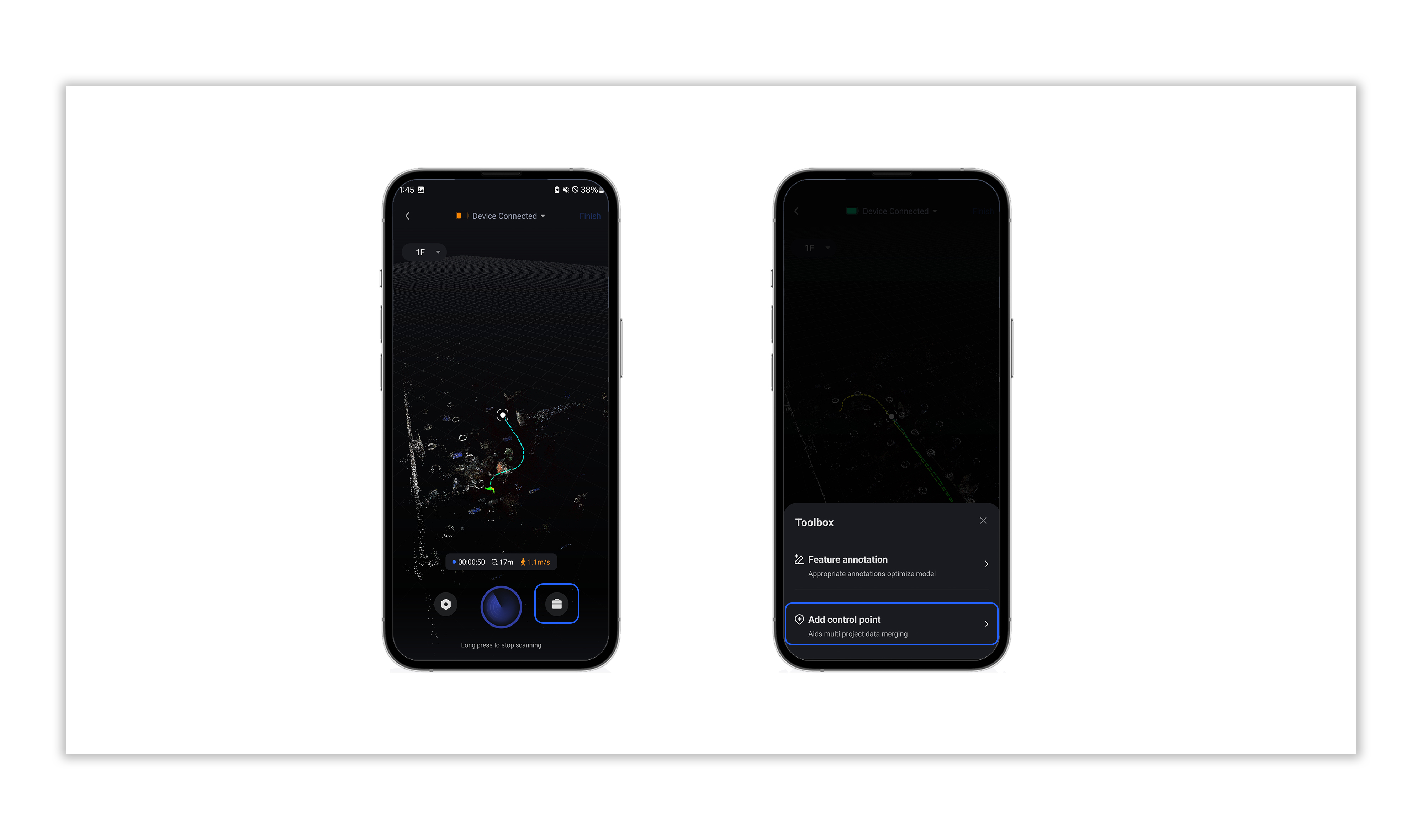
2.2 Select the <Control Point Number> to complete the addition;

https://global-public.realsee-cdn.com/release/pagepress/MYvDyUTX/uploads/8edaf0c9-6fcf-4bfe-bdf2-b7f524245422.jpg

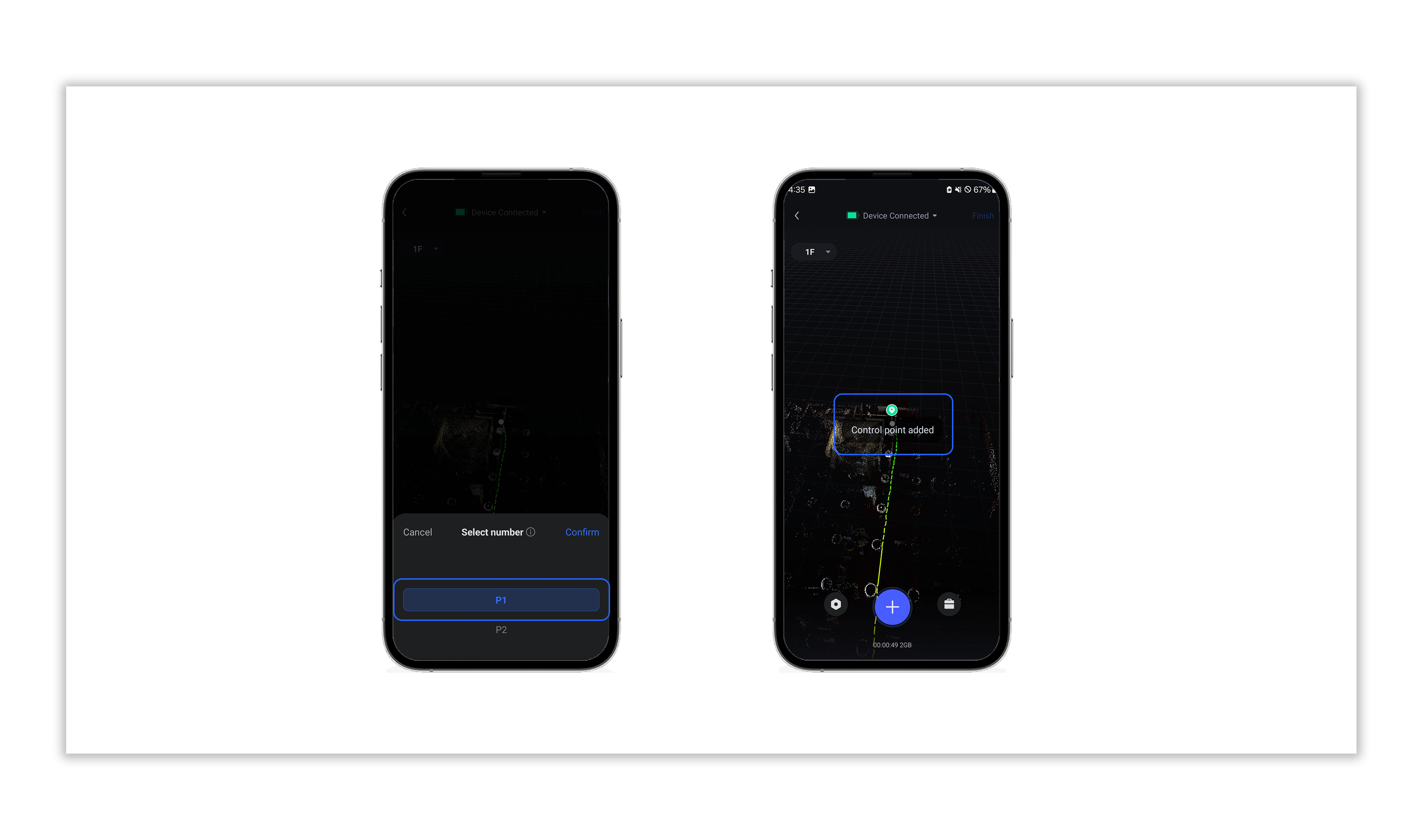
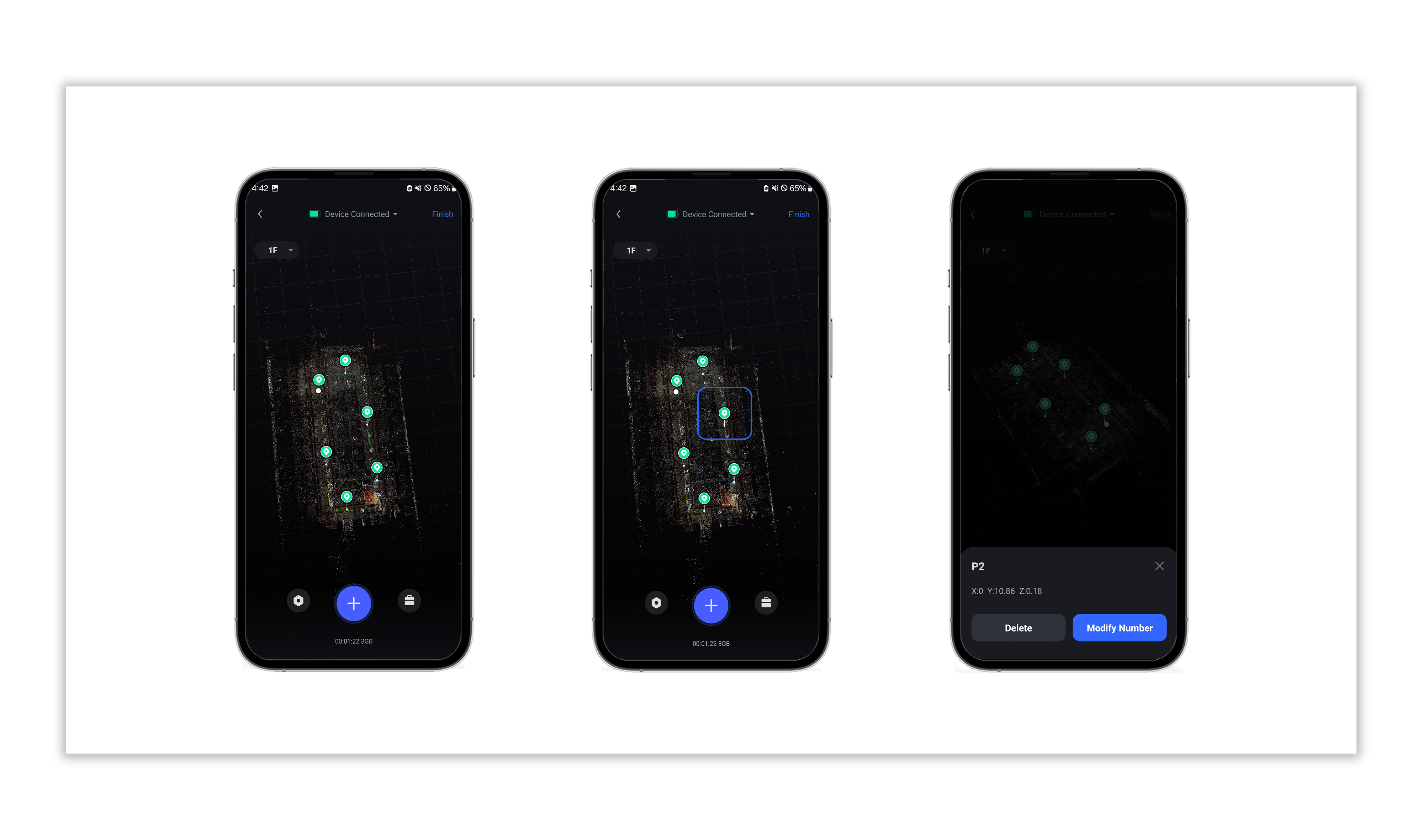
2.3 The location information of the added control points will be recorded in the collection track in the form of tags;

2.4 Tap the location information of the added control points to delete or modify them;

https://global-public.realsee-cdn.com/release/pagepress/rYZUlPaA/uploads/63e3f725-5f23-4831-abb2-b314d43d6111.jpg

Note: If you want to stitch multiple tracks via control points, the number of control points with the same name between the two tracks must be ≥ 5; and the control points with the same name must be at the same absolute position.

Was this article helpful?

YesNo

Previous

Add Close-up Photos
  • Product
    • Galois
    • Realsee G1
    • 360 Camera
    • Mobile phone
  • Solution
    • Real Estate Photographer
    • Real Estate Agency
  • Resources
    • About Us
    • Partners
  • Quick links
    • Realsee App
    • Console
    • Help Center
    • Legal agreements
  • Contact Us
    LinkedInFaceBookYoutubeXRedditWhatsApp
Realsee
©Copyright 2026 Beike Realsee Technology (HK) Limited All rights reserved|Various trademarks held by their respective owners.