One-Stop 3D Tour Solution for Real Estate & AEC Pros
We will contact you within 48 hours. For product support or potential cooperation, please contact us at hello@realsee.ai

Ultimate One-Stop 3D Tour Solution for Real Estate
Got Questions? Contact Us!
134MP Automatic 3D Tour for Indoors & Outdoors
Capture 3D tours indoors and outdoors with Galois 3D LiDAR Camera, equipped with 940nm LiDAR, 4/3-inch CMOS sensor, and 5-bracket HDR.
Advanced LiDAR: Precision Tours & Instant Floor Plans
Galois LiDAR sensors deliver ultra-accurate 3D tours and enable instant automatic floor plan generation for layout visualization.
Boost Listings with OBJ, E57, RAW, 134MP Panos & More
Download RAW images, 134MP Panos, Floor plans, OBJ 3D models, E57 Point Cloud—all from a single scan. Effortlessly refresh your 3D tours to attract buyers.
Pay-As-You-Go Model with No Monthly Fees
No monthly fees! Capture, upload, and edit 3D tours for free. New users receive credits to explore full 3D tour creation & sharing process at no cost!
LiDAR Scanner: 134MP 3D Tours for Any Space
Precision LiDAR scan, auto point cloud stitching, 4/3 CMOS, 5-bracket HDR. Adaptable anywhere. Auto floor plans, RAW, OBJ, E57.
Explore Galois 3D LiDAR Camera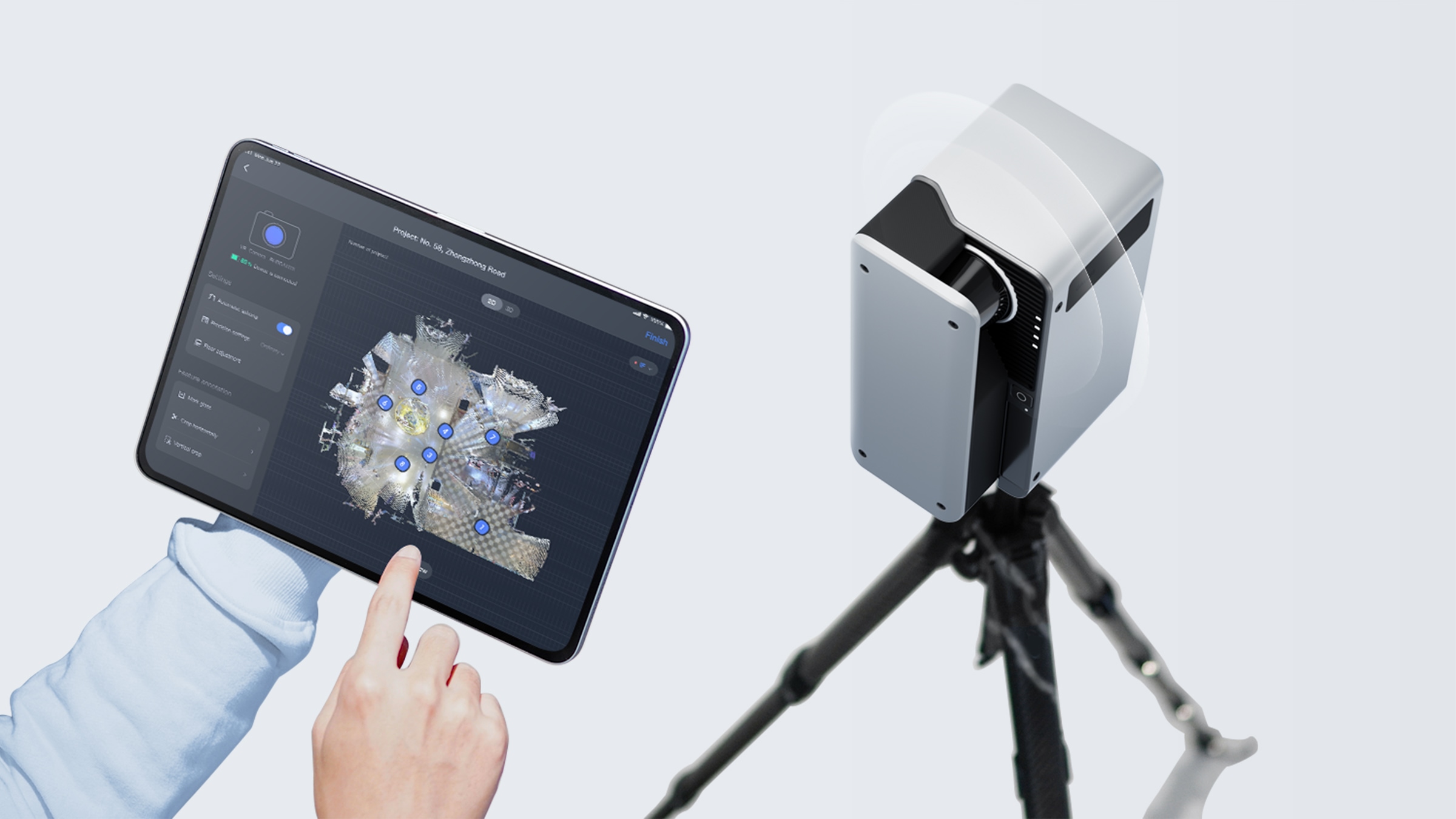
LiDAR Precision &134MP True Color: Galois Delivers Any-Space Reality Tours
Got Questions? Contact Us Now!True-to-Reality Any-Space 3D Tour & Floorplan Creation with Galois LiDAR Scanning
True-to-Reality LiDAR Scan: LiDAR captures complex spaces infrared can't – accuracy assured.
One-Click Magic: Create immersive 3D walkthroughs, dollhouses & AI-powered Floorplan instantly.
Outdoor-Friendly: LiDAR thrives in outdoor environments – no lighting limitations.
Smart Scanning: Capture 1,000 sq ft in 15 mins – zero manual stitching needed.
Galois 3D LiDAR: True Color, 134MP Ultra Detail, Reality That Sells
- Residential
- Retail
- Tourism
- Outdoor
Captured with Galois 3D LiDAR Camera

What Property Marketing Pros Say about Realsee Galois 3D LiDAR Camera

Hugh Hou
An in-depth, objective evaluation of Realsee Galois 3D LiDAR camera.
See Details
David Rosillo
David Rosillo from Spain highly recommends the Realsee Galois 3D LiDAR Camera.
See Details
Brett Conyers
Brett Conyers from Australis showcase the thorough introduction of Realsee Galois 3D LiDAR Camera
See Details
David Ulivelli
David Ulivelli from Italy praises the Realsee Galois 3D LiDAR Camera for its exceptional accuracy!
See Details
Nick Powell
Nick showed us an in-depth review of the Realsee Galois 3D LiDAR Camera!
See Details
WGAN-TV
Intro to REALSEE LiDAR Camera and 3D Digital Twin Hosting Services
See Details
Martin Vargas
Wondering how to link the Aerial 3D Tour with the Ground 3D Tour? Check out Martin's incredible 3D tours!
See Details
Nick Powell
Let's hear Nick's feedback on Realsee's recently launched virtual tour editing feature!
See Details
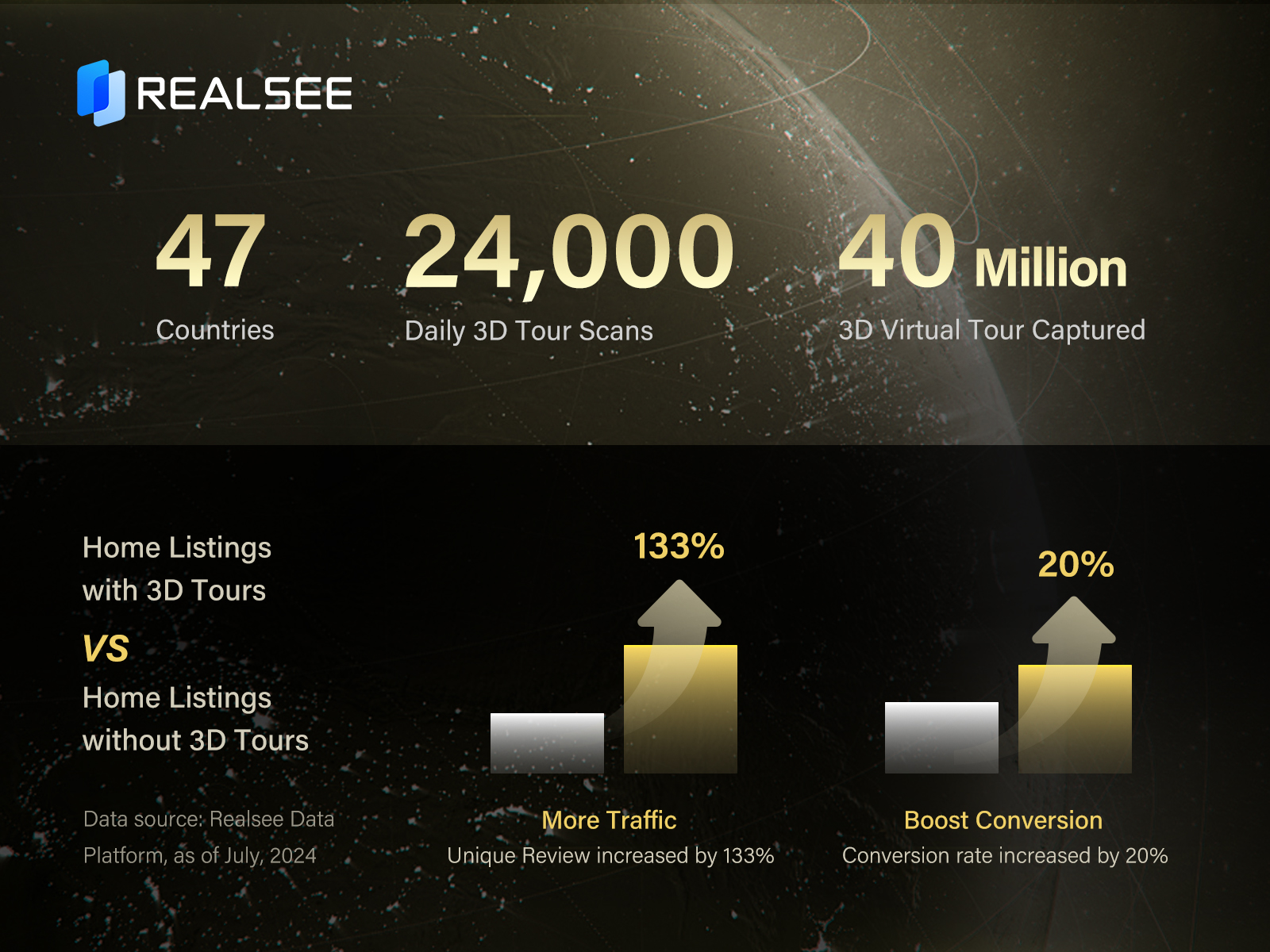
Leading: The World's Largest 3D Spatial Database
Got Questions? Contact UsRealsee is the exclusive 3D tour provider for Ke Holdings Inc. (NYSE: BEKE).
Realsee has captured over 40,000,000 3D virtual tours, covering approximately 35.8 billion sqft, making it the world's largest 3D spatial database (Data source: Realsee Data Platform, as of July, 2024).
Realsee averages approximately 24,000 daily 3D virtual tour captures (Data source: Realsee Data Platform; Sample period: January to July 2024).
BEKE platform potential buyers and agencies successfully connected about 175,000 Realsee Live 3D calls daily for virtual open houses, with agencies hosting over ten times more open houses than traditional methods (Data source: Realsee Data Platform, January to July 2024).
Listings with Realsee 3D Tours get 133% more unique views and 20% higher lead conversions (Data source: Realsee Data Platform, as of June, 2024)