Capture, share & collaborate: 3D virtual tour made easy - Realsee
  • Sign In
  • Product
  • Solution
  • Gallery
  • Support
  • Resources
  • Store
  • Product
    The effortless all-in-one 3D tour solution that doubles your profits.
    • Capture Device
      • Galois
        GaloisHot
        3D LiDAR Camera
      • REALSEE G1
        REALSEE G1
        Smartphone Gimbal
      • 360 Camera
        360 Camera
        Wide Compatibility
      • Mobile phone
        Mobile phone
        Capture Easily
    • 3D Tour Features
      • Editor Features
        Editor FeaturesHot
        Powerful 3D Tour Editing Features
  • Solutions
    Leading 3D Tour Producer, Tailored for Real Estate
    • Client Type
      • Real Estate Photographer
        Real Estate Photographer
        Effortless 3D tour, double your profits in no time.
      • Real Estate Agency
        Real Estate Agency
        Boost your listings with Realsee's pay-as-you-go 3D tour solution.
      • Real Estate Brokerage
        Real Estate Brokerage
        Professional-grade 3D solutions for real estate brokers.
    • Case Study
      • Commercial Real Estate
        Commercial Real Estate
        Professional LiDAR scanning for commercial spaces.
      • Residential Real Estate
        Residential Real Estate
        LiDAR-powered virtual home tours that accelerate sales.
      • Museum
        Museum
        Immerse visitors with LiDAR-captured 3D museum experiences.
      • Travel & Tourism
        Travel & Tourism
        Transform destinations with interactive LiDAR 3D tours.
  • Support
    Get help and resources for our services.
    • Support
      • Help Center
        Help Center
        Find FAQs and guides for your questions.
      • Contact Us
        Contact Us
        Contact our team for personalized inquiries.
  • Resources
    Explore valuable information and insights.
    • Resources
      • About Us
        About Us
        Learn more about our mission and team.
      • What's New
        What's New
        Discover what's new and improved.
      • Blog
        Blog
        Stay updated with latest news & creator stories via our blog.
      • Partners
        Partners
        Discover partnership opportunities with us.
  • Store
    Browse our products and services.
    • Plans
      • Credit Plans
        Credit Plans
        Purchase Realsee credits for 3D tour hosting and downloads with a pay-as-you-go option.
      • New User Free Trial
        New User Free Trial
        Learn about free benefits for new users.
    • Realsee Cameras
      • Galois M2
        Galois M2
        Purchase the professional LiDAR camera to elevate your business.
      • G1 Gimbal
        G1 Gimbal
        Contact sales for G1 gimbal inquiries.
Contact Us
Capture, share & collaborate: 3D virtual tour made easy - Realsee
Product
  • Product
    The effortless all-in-one 3D tour solution that doubles your profits.
    • Capture Device
      • Galois
        GaloisHot
        3D LiDAR Camera
      • REALSEE G1
        REALSEE G1
        Smartphone Gimbal
      • 360 Camera
        360 Camera
        Wide Compatibility
      • Mobile phone
        Mobile phone
        Capture Easily
    • 3D Tour Features
      • Editor Features
        Editor FeaturesHot
        Powerful 3D Tour Editing Features
Deliverables
  • Deliverables Downloads
Solution
  • Solutions
    Leading 3D Tour Producer, Tailored for Real Estate
    • Client Type
      • Real Estate Photographer
        Real Estate Photographer
        Effortless 3D tour, double your profits in no time.
      • Real Estate Agency
        Real Estate Agency
        Boost your listings with Realsee's pay-as-you-go 3D tour solution.
      • Real Estate Brokerage
        Real Estate Brokerage
        Professional-grade 3D solutions for real estate brokers.
    • Case Study
      • Commercial Real Estate
        Commercial Real Estate
        Professional LiDAR scanning for commercial spaces.
      • Residential Real Estate
        Residential Real Estate
        LiDAR-powered virtual home tours that accelerate sales.
      • Museum
        Museum
        Immerse visitors with LiDAR-captured 3D museum experiences.
      • Travel & Tourism
        Travel & Tourism
        Transform destinations with interactive LiDAR 3D tours.
Gallery
Support
  • Support
    Get help and resources for our services.
    • Support
      • Help Center
        Help Center
        Find FAQs and guides for your questions.
      • Contact Us
        Contact Us
        Contact our team for personalized inquiries.
Resources
  • Resources
    Explore valuable information and insights.
    • Resources
      • About Us
        About Us
        Learn more about our mission and team.
      • What's New
        What's New
        Discover what's new and improved.
      • Blog
        Blog
        Stay updated with latest news & creator stories via our blog.
      • Partners
        Partners
        Discover partnership opportunities with us.
Store
  • Store
    Browse our products and services.
    • Plans
      • Credit Plans
        Credit Plans
        Purchase Realsee credits for 3D tour hosting and downloads with a pay-as-you-go option.
      • New User Free Trial
        New User Free Trial
        Learn about free benefits for new users.
    • Realsee Cameras
      • Galois M2
        Galois M2
        Purchase the professional LiDAR camera to elevate your business.
      • G1 Gimbal
        G1 Gimbal
        Contact sales for G1 gimbal inquiries.
  • Contact Us
  • Sign In
  • Get Started Free

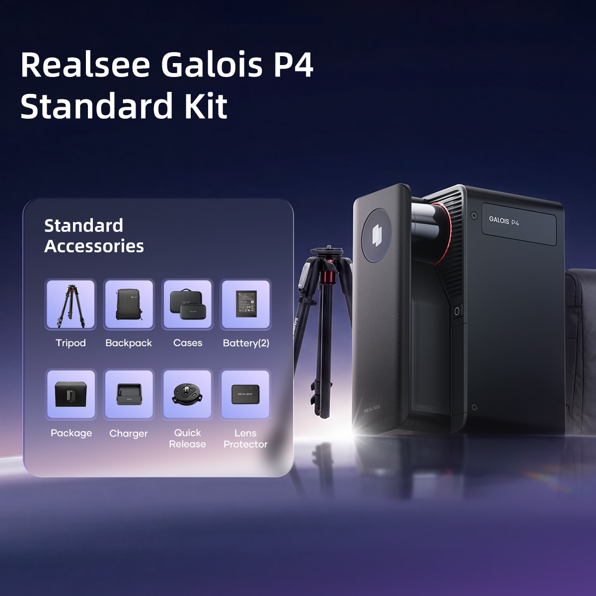
GALOIS P4 Standard Kit - Special Offer

$7,199

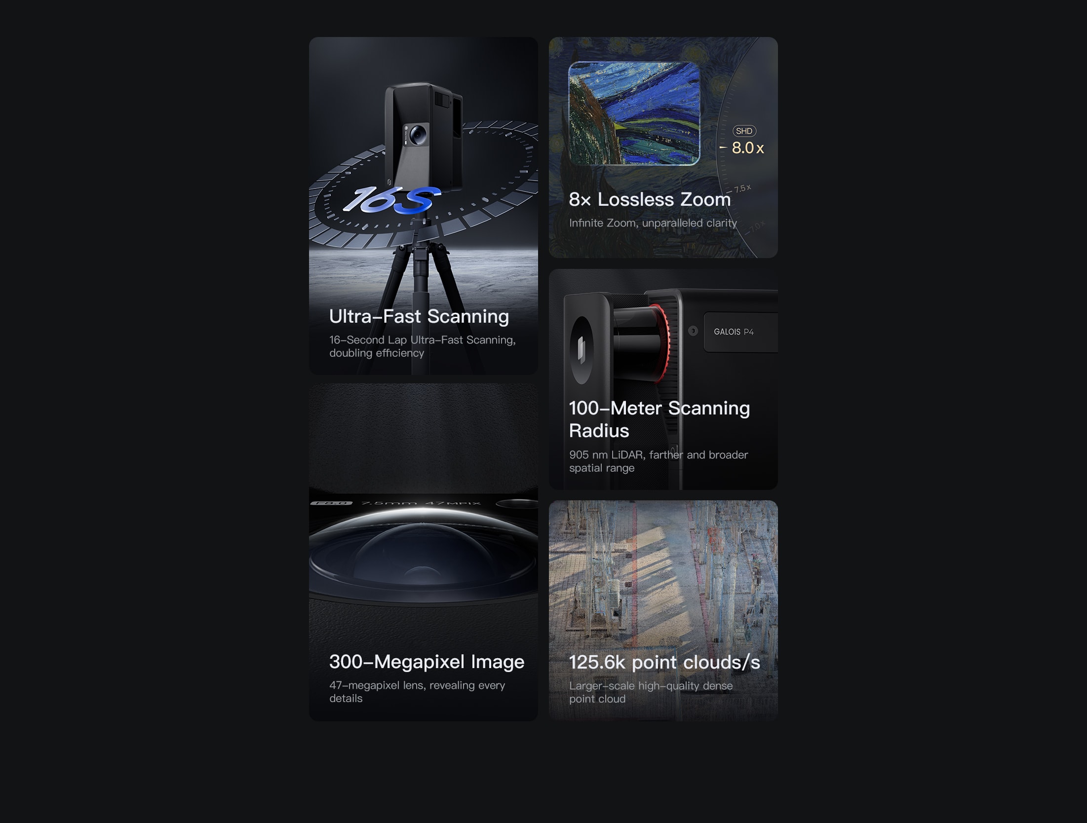
• 905 nm Laser LiDAR
• 300-Megapixel Image
• 4/3-inch CMOS Sensor
• 8x Lossless Zoom
• Number of exposures per HDR frame: 5
• 100-Meter Scanning Radius
• 50 Credits

Purchase Quantity (Limit of 10 Items)
Total 1 item,Total: $7,199

[Confirmation of receipt]
Please ensure that the hardware equipment is signed for in person. Please confirm that the outer packaging is intact and undamaged, that the accessories are complete and that the quantity is correct before signing for the product in the presence of the person signing for the product, and if you find any problems, please take a photo and refuse to sign and contact us.

[About Data]
All relevant data is from Realsee Labs, dimensions and weight may vary depending on configuration and manufacturing process.

[Warranty]
[1] Hardware products provide 1 year warranty service (not including tripod, data cable and other accessories), due to the product itself quality problems caused by failure or damage, within the scope of the warranty repair or parts replacement, etc., no additional service charges.
[2] The service charge and the price of accessories are reference prices, please refer to the "Repair Quotation" issued by Realsee after confirming the specific repair items (the service charge for different product models may be adjusted; the price of accessories may be adjusted due to factors such as procurement batches, time and suppliers).
*The price of parts is not the selling price of parts, repair parts are not sold separately.
[3] For more information, click here to check our Shipping and Delivery Policy, and Return & Replacement Policy.

If you have any questions, please contact customer service for advice.
Email: support@realsee.ai

  • Product
    • Galois
    • Realsee G1
    • 360 Camera
    • Mobile phone
  • Solution
    • Real Estate Photographer
    • Real Estate Agency
  • Resources
    • About Us
    • Partners
  • Quick links
    • Realsee App
    • Console
    • Help Center
    • Legal agreements
  • Contact Us
    LinkedInFaceBookYoutubeXRedditWhatsApp
Realsee
©Copyright 2026 Beike Realsee Technology (HK) Limited All rights reserved|Various trademarks held by their respective owners.
Highlights

Highlights

镜头一扫,全场色彩尽收

True. Fast. Precise.

Peak Imagery, Second-Level Efficiency, Expansive Data.
Galois P4 Pursues Perfection, Redefining the Frontiers of 3D Reconstruction.

Perfect Visuals, Flawless Quality.

Perfect Visuals, Flawless Quality.

Galois P4 presents ultra-high-definition visuals, achieving unparalleled realism that captures every detail and immerses you in every single capture

Ultra-High-Definition Imagery

Galois P4 is equipped with a next-generation 4/3-inch CMOS sensor and a 47-megapixel high-resolution color lens module, directly generating stunning 300-megapixel ultra-high-definition panoramic images that set the industry benchmark for picture quality.

Zoom in 8x, still sharp without compromise.

Galois P4 redefines the limits of VR clarity with its 8x lossless zoom technology. Distant window views feel as if you're right before the glass, while microscopic structures reveal sharply defined edges. From sweeping vistas to the finest details, everything comes under your crystal-clear command.

Multispectral sensors, encompassing the full spectrum.

Galois P4 is equipped with a built-in multispectral sensor that captures the reflective information of objects across specific wavelengths, including visible light and near-infrared. This technology significantly enhances the authenticity of image colors and details while revealing hidden features invisible to the human eye.

Balanced light and shadow, every layer revealed

The HDR technology of the Galois P4 delivers a balanced world of light and shadow that closely mirrors real human vision—highlights remain vivid without overexposure, shadows retain rich detail, and every inch of space you explore feels authentic and tangible.

Efficiency redefined—rendered in seconds.

Galois P4 sets a new industry benchmark for efficiency with end-to-end second-level response and zero-threshold operation.

Easy to Capture

Easy to use, no experience needed — start capturing in VR right away.

Ultrafast Scanning; Seamless Stitching

A full scan takes only 16 seconds, with point-to-point stitching completed in just 1 second—doubling the efficiency of capture workflows. With Galois P4, a 100㎡ space can be fully captured in just 8 minutes.

Co-Capture

It supports multi-user partitioned parallel capture, enabling synchronized and efficient progress. Data is automatically and seamlessly stitched into a unified project, simplifying the handling of large-scale spaces and significantly accelerating

High-definition Touchscreen

No phone control needed — lift, tap, and capture blind with one touch for even simpler operation

Scan Farther. Capture Denser. View Wider.

Galois P4 combines long-range deep detection, dense point capture, and a wide field of view to reveal the intricate textures of the world with ultimate spatial precision

Scan Far——100-meter scanning radius

Galois P4 extends its capture range up to 100 meters, delivering greater spatial penetration and deeper detection for higher precision in spatial understanding—empowering decisions that reach as far as your scan.

Capture dense—125.6k point clouds/s

Equipped with a 905nm LiDAR, the Galois P4 captures 125.6k point clouds/s, enabling the collection of highly detailed 3D spatial data. Every nuance of space is revealed through its dense and precise point cloud—leaving no detail unseen.

Wide perspective — 360° × 213.25° FOV.

Galois P4 breaks scanning boundaries with a massive 360° × 213.25° field of view, covering wider areas and leaving no blind spots—delivering truly higher efficiency and more complete capture.
  • High-precision

    High-precision

    Equipped with LiDAR and advanced sensors, Galois P4 enables millimeter-level scanning with an absolute error of less than ±10 mm.

  • Multi-scenario

    Multi-scenario

    Unaffected by varying lighting conditions—delivering consistent, high-quality scans indoors, outdoors, and in both low and bright light.

Downable Deliverables

Galois P4 generates a wide variety of deliverables to meet diverse enterprise needs, allowing flexible selection on demand.

High-quality Spatial Data

LiDAR scanning generates high-precision point cloud files (e.g., .ply, .e57) and, powered by Realsee's proprietary algorithms, automatically produces detailed 3D models (e.g., .obj, .fbx, .gltf, .glb). These outputs are compatible with professional software such as Autodesk suites, SketchUp, and Cloud Compare for seamless management and application.

RAW File Image

Galois P4 captures image data directly in RAW format, preserving rich dimensional information and offering greater flexibility for adjustments. By processing algorithms on RAW data, it achieves more refined and precise image results.

Multiple Derivative Deliverables

After capture, Galois P4 automatically generates multiple derivative deliverables—such as 3D models, floor plans, panoramas, and marketing videos—supporting multi-scenario enterprise applications and meeting diverse business needs.

Technical Specifications

Appearance

Galois P4 3D LiDAR Camera

Black

Dimensions

Height:20.95 cm(8.2 inch)
Width:10.4 cm(4.09 inch)
Length:15.2 cm(5.9 inch)
Weight:2.6 kg (5.73 lbs, including battery)

Laser LiDAR Scanner

905nm Laser LiDAR
0.1-100m range(@90% reflectivity)
360° x 213.25° field of view
< ± 10 mm measurement error (@0.1-15m)
Sacn Rate: 125,600 pts/sec
Class 1 Safety Rating

Imaging

Cemera:Approx. 48 MP
CMOS:4/3 inch
Number of exposures per HDR frame:5
Panorama Output:320 MP, 360° × 145.08° FOV
White Balance:Automatic

Performance

Data Acquisition: 16 sec per scan point
RAM: 4GB LPDDR5
Internal Storage: 512GB
RTK: Yes

Processor

NVIDIA Jetson Orin Nano

Battery

20V 3.25A 65W Type-C 3-hour operation per battery (2 included) ~2.5 hours full charge

Operating Environment

Working Temperature: 0°C to 40°C (32°F to 104°F)
Charging Temperature: 10°C to 45°C (50°F to 113°F)
Storage Temperature: -10°C to 50°C (-14°F to 122°F)

Packaging Contents

Galois P4
Battery
Fisheye Lens Cap
LiDAR Cover
Warranty Card
65W Type-C Power Adapter
Washable Lens Cloth

Realsee App

Realsee App
Download Now

Deliverables

Point Cloud

Point Cloud Formats:e57, ply

3D Model

Model Formats:obj, fbx, gltf, glb

Panorama

24576 × 12288 pixels
360° × 145.08° field of view

Spatial Video

1080p / 720p HD video

1. P4 in standard mode, in a sunny outdoor environment, triggering the hardware to complete the acquisition time.

2. The generated panoramic image has a resolution of 24576px * 12288px, exceeding 300 million pixels. The final delivered panoramic image size may vary slightly; the actual result shall prevail.

3. The radar parameters used by P4 are: 0.1-100 meter scanning radius (@ 90% reflectivity).

4. The actual number of point clouds scanned by the P4 radar in an enclosed space.

5. If feature points were constructed during calibration, the 3D features of the point cloud were reprojected onto the 8000x4000 pixel panoramic image. The reprojection error of the feature points is 2 pixels.